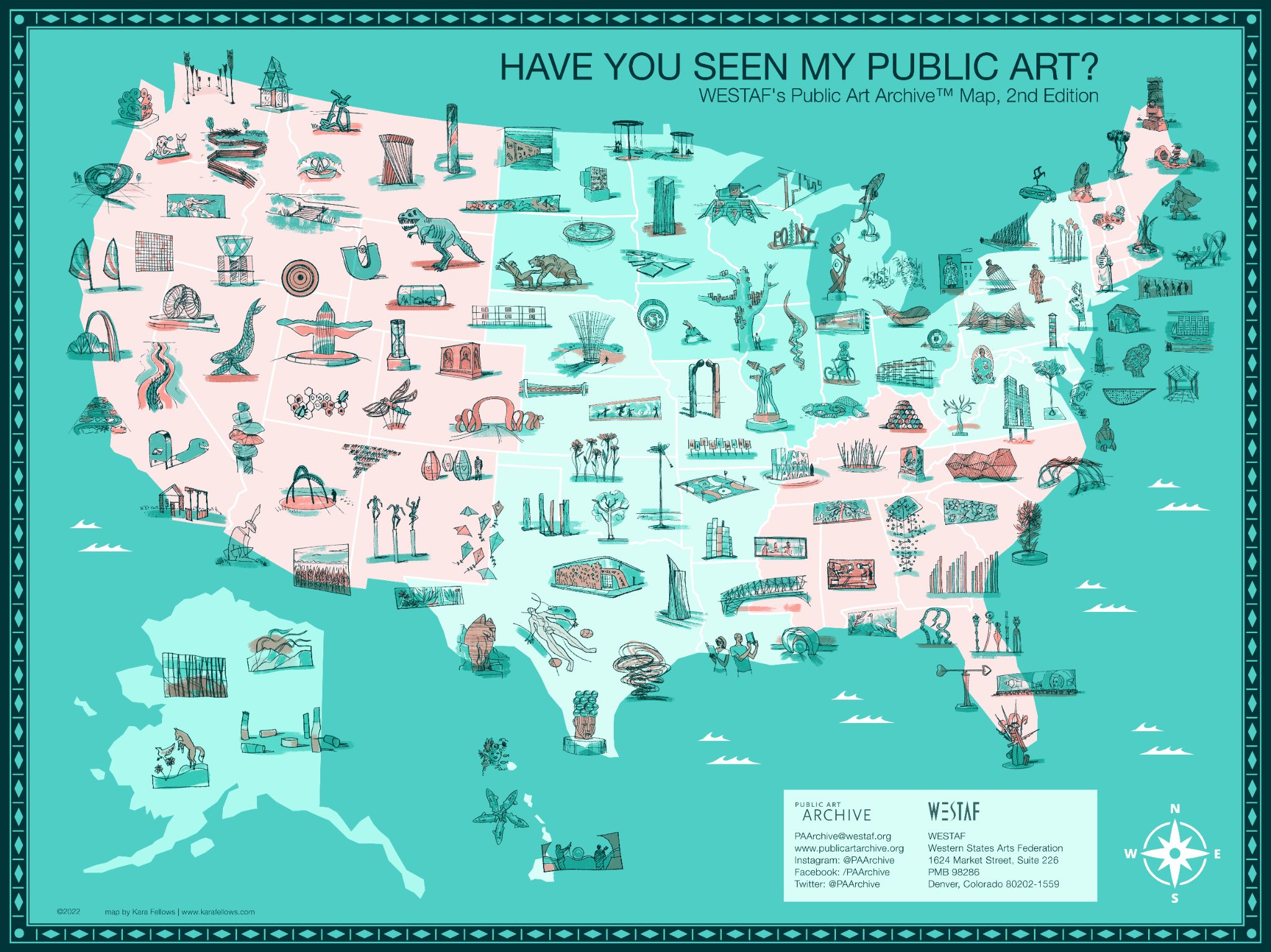
10 years ago, CaFÉ’s fellow WESTAF program, the Public Art Archive™ (PAA), commissioned the first edition of the Have You Seen My Public Art? Map, illustrated by Kenny Be, to bring visibility to the program and its mission to make public art more public. In celebration of a decade of archiving almost 20,000 public artworks around the U.S. and abroad, PAA recently commissioned a second edition of the map, illustrated by Boulder-based artist Kara Fellows, which launched in early September.
The second edition of the map includes 144 artworks across all 50 states created by over 176 unique artists and studios within the last 10 years. In order to find these artworks, PAA called upon artists and organizations to submit their artworks on CaFÉ as part of a juried competition for a spot on the map. To showcase how CaFÉ was used in the process and hear how the anniversary map came together, we reached out to our colleagues at the Public Art Archive, Lori Goldstein and Alison Verplaetse. Read all about their experience and follow their timeline of the project from start to finish!
January
Preparations Began
In early 2022, the Public Art Archive team began their preparations for commissioning the second edition of the Have You Seen My Public Art? Map. In its conception, three project goals were outlined: showcasing works from typically underrepresented communities in public art, BIPOC artists, or works that touch on themes of inclusion and social equity; highlighting the diversity of artwork types that constitute public art; and, representing as many states and U.S. territories as possible.
February
Kara Fellows Selected to Illustrate the Map
The Public Art Archive team did an extensive search for artists that had experience with illustrated maps. “We were looking for someone whose illustrations could take their own creative form—especially because this project entailed illustrating another person’s artwork,” said Lori Goldstein, manager of the Public Art Archive. Soon the team found illustrator Kara Fellows, who specializes in advertising and editorial illustration, hand lettering, and maps. “We came across Kara’s website and found her work both charming and effective as a tool for artistic mapping and storytelling.” Based in Boulder, Colorado (not far from Denver-based PAA), the team expressed their enthusiasm about supporting and collaborating with the local creative economy.
March 1
Call for Entry Opened
The Public Art Archive invited artists and organizations that were the creators, commissioners, and/or owners to submit images of public artworks created within the last 10 years. For the purposes of this project, artworks are considered “public art” if they are in a place accessible or visible to the public without an entrance fee.
CaFÉ collected all submissions. Each artist or organization could submit up to 20 pieces of art, and upload up to eight images and two videos per artwork. There was no fee to apply. The application form collected information for each public artwork about its ownership or commission information, location, and photographer credits. Artwork details were generated from the associated media records, which helped to make artist submissions more efficient if they already documented these artworks in their CaFÉ portfolios. This information was later used to properly credit and supplement the artwork image in the final iteration of the map.
The PAA team came up with numerous ways to promote the call for entry in order to ensure there was artwork submitted from all 50 states. It was shared directly with the PAA & WESTAF networks, entities that use the Public Art Archive’s Collection Management System, the Public Art Exchange (PAX) network, and the Americans for the Arts’s Public Art Network (PAN). PAA also worked with CaFÉ to send a promotional e-blast to public artists registered with CaFÉ.
April 30
Call for Entry Closed
After being open for 60 days, the call for entry closed with over 500 submissions contributed by almost 300 artists and organizations across the United States. Public artworks submitted varied greatly in type, placement, disciplines, and themes.
May 1-3
Submissions Screened for Eligibility
Before the submissions were juried, the PAA team reviewed the artworks to ensure they were eligible for the projects. To be eligible, the artworks must have been created in the last 10 years (2012-2022) and installed or exhibited in a place that is free and accessible to the public. The submission also had to have complete information for identifying the artwork or artist, and had to have good enough image quality so the map illustrator would be able to render the artwork.
May 3-10
Submissions Juried by WESTAF Staff
All eligible submissions were juried by 12 staff members representing a range of diverse departments across WESTAF. The entries were categorized by each U.S. region, and multiple jurors were assigned to each one. In order to meet the project’s goals, the following criteria were given to the jury to consider while scoring the artwork:
Does the work have a strong visual impact?
Is the work’s central theme one of social awareness, inclusion, or equity?
Does the work demonstrate creativity and originality in public art?
Does the work help uncover underrepresented narratives and communities in public space?
Do your selections represent a wide variety of work types (ex: sculpture, mural, installation, earthwork, etc.)?
May 10-17
Top-Scored Entries Identified
Once the jurors’ entered their scores for the submissions, the PAA team identified the top-scored artworks from each region. “While we had a great array of artworks for Kara to choose from for her illustrations, we had to also make sure that there was representation from each state and that each region looked balanced,” said Goldstein. “At certain points, this took additional direct outreach to particular states to fill in areas lacking public art. We also wanted to ensure that there was a true range of public artwork types—not just outdoor sculpture!”
At the end of the jury process, 144 artworks were selected to be featured on the map. The PAA team notified the artists and organizations through CaFÉ about the status of their submissions. All artworks—regardless of whether they were selected—were archived in the Public Art Archive database to continue the mission to make public art more public through increased access and visibility.
May 17-
July 31
Artist Illustrated the Map of Selected Artwork
With the artworks selected, the images and a spreadsheet of the artwork information were handed off to Kara Fellows to begin illustrating the second edition of the Have You Seen My Public Art? Map. “We really let Kara lead in terms of creating a visual balance on the map,” said Goldstein, explaining that sometimes artworks weren’t placed in their exact geographic location within a state or were rotated around a particular area so the pieces would fit better. “Trusting the artist’s vision is something that is so important in the world of public art, especially when there are so many collaborators on the project, and in some ways, this particular project reflected a similar commissioning and design process that many organizations using PAA go through.”
In addition to illustrating the selected artworks, Fellows had to illustrate other map elements such as the border, compass rose, and text. The PAA team and Fellows met several times to review and revise the map and the illustrations to bring it to its final form in mid-August.
August 15 -
September 1
Interactive Map Created
The Public Art Archive has always valued technology-driven tools to increase engagement with public art, and this project was no different. In addition to the illustrated map, PAA created an interactive version on its website for visitors to browse the featured artworks. Using exported data from the submissions on CaFÉ and public-facing records on the Public Art Archive, users can click on each illustration to see more information about the artwork and artist, where the piece is located, materials used, etc. “This type of work required multiple eyes to make sure we didn’t miss anything or link to the wrong project,” said Goldstein, adding “the most wonderful thing about working in digital space is that we can go back and edit as needed. As new artists and organizations add more context to the artwork records on the Public Art Archive, this only helps to make the map and the stories embedded within the public art more vibrant and powerful.”
September 9
Have You Seen My Public Art? Map, 2nd Edition Released
After nine months since the project began, the second edition of the Have You Seen My Public Art? Map was released. The map can be viewed and interacted with on the Public Art Archive website. Visitors can also view artwork analyses of the project, including a breakdown of the artwork types, placement types, and installation types featured.
While reflecting on the project, Goldstein described the experience of using CaFÉ to collect the artwork submissions. “An element to working with CaFE that is so powerful is the ability to leverage the program’s existing network/ecosphere of artists,” she said. “For this project, we were looking to cast a really wide net for public art projects that included not just those major projects with big budgets and major press. A lot of times, these artists aren’t on the general public art networks, and we really believe that utilizing CaFE for this call boosted our abilities to reach these more obscure networks.”
The map will be distributed widely, for free, via digital networks and used in occasional Public Art Archive and WESTAF collateral material (including large-scale postcards). The PAA Anniversary Map postcard is also available for pre-order.
In final remarks, Goldstein says, “We also want to take a minute to shout out all the artists and organizations that submitted to this project. We are so pleased that everyone took time out of their busy schedules to contribute, and we plan to keep expanding our resources and continue giving back to the public art community in the same way that the community contributes to PAA.”
Written by Communications Coordinator Justine Chapel

